Movement Through the Story

Journeys

Follow the journeys of Abraham and of Paul stop by stop, in the order the Bible gives them.

Each journey has its own page with the verses and the people involved. The maps show the stops in the order of the text. Lines join the stops; they are not roads.

Journey 1

Abraham’s Journey

From Ur through Haran into Canaan, down to Egypt, and back again.
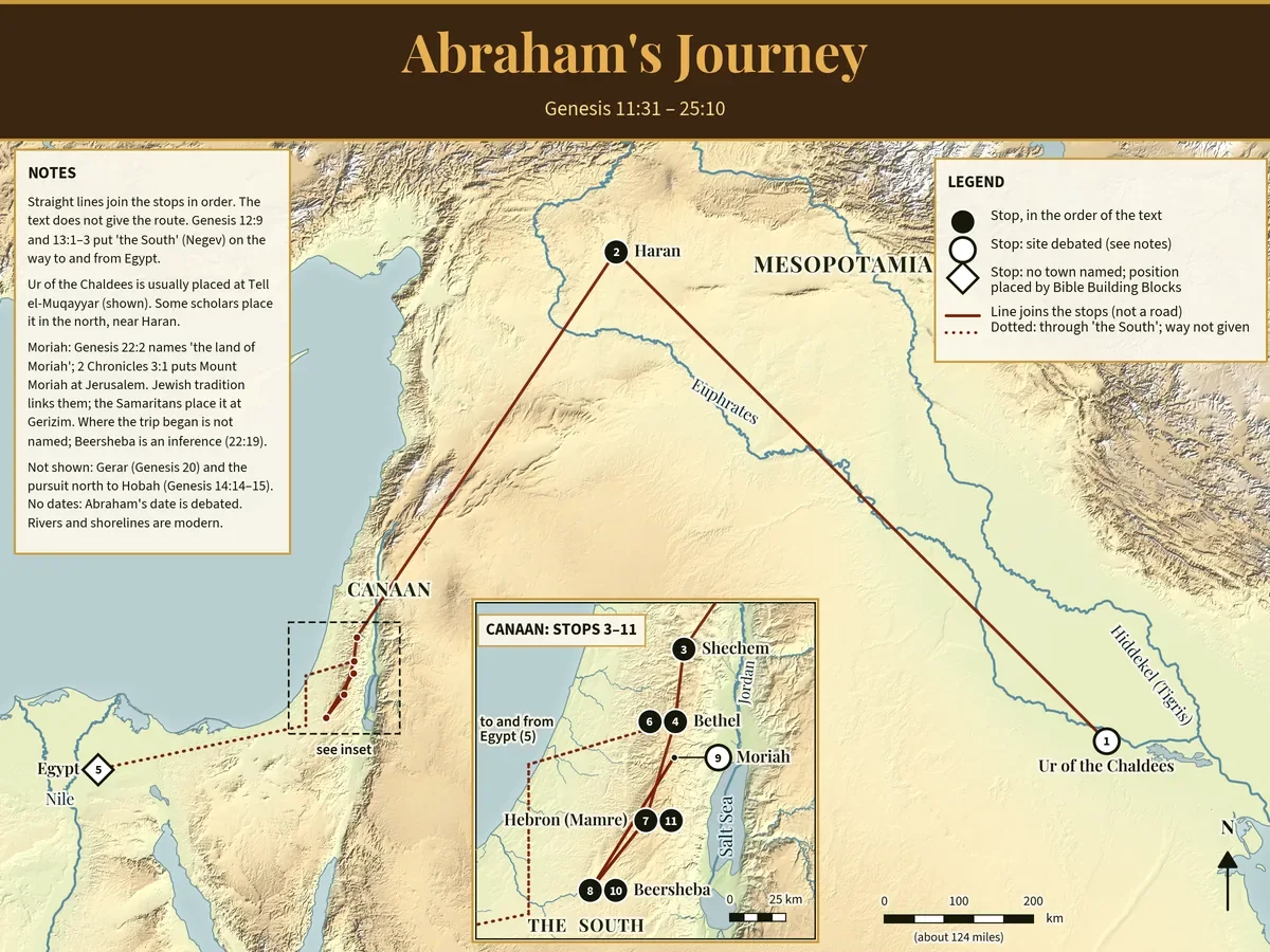
Map of Abraham's journey across the Near East. Numbered stops run from Ur of the Chaldees in southern Mesopotamia north to Haran, then south to Canaan. An inset of Canaan shows Shechem, Bethel, Hebron (Mamre), Beersheba and Moriah, and a dotted line runs through the South to Egypt and back.
Abraham’s journey from Ur to Canaan, with the trip to Egypt. Lines join the stops; they are not roads. Select the map to view it full size.

Verses: Gen 11:31–25:10 The Patriarchs

Sources and limits

  • Straight lines join the stops in the order of Genesis. The text does not give the route.
  • Ur is shown at its usual site, Tell el-Muqayyar; some scholars place it in the north, near Haran. Moriah is linked to Jerusalem by 2 Chronicles 3:1 and by Jewish tradition.
  • The text names no town in Egypt, so that point is ours. Gerar and the chase north to Hobah are not shown.
  • Built by Bible Building Blocks from public-domain and open data: elevation from the US Geological Survey, coastlines and rivers from Natural Earth, and town points from Wikidata. Names follow the World English Bible, each checked against its verse. Shorelines are modern.
Journey 2

Paul’s First Journey

Paul and Barnabas travel from Antioch in Syria to Cyprus and the cities of southern Galatia.

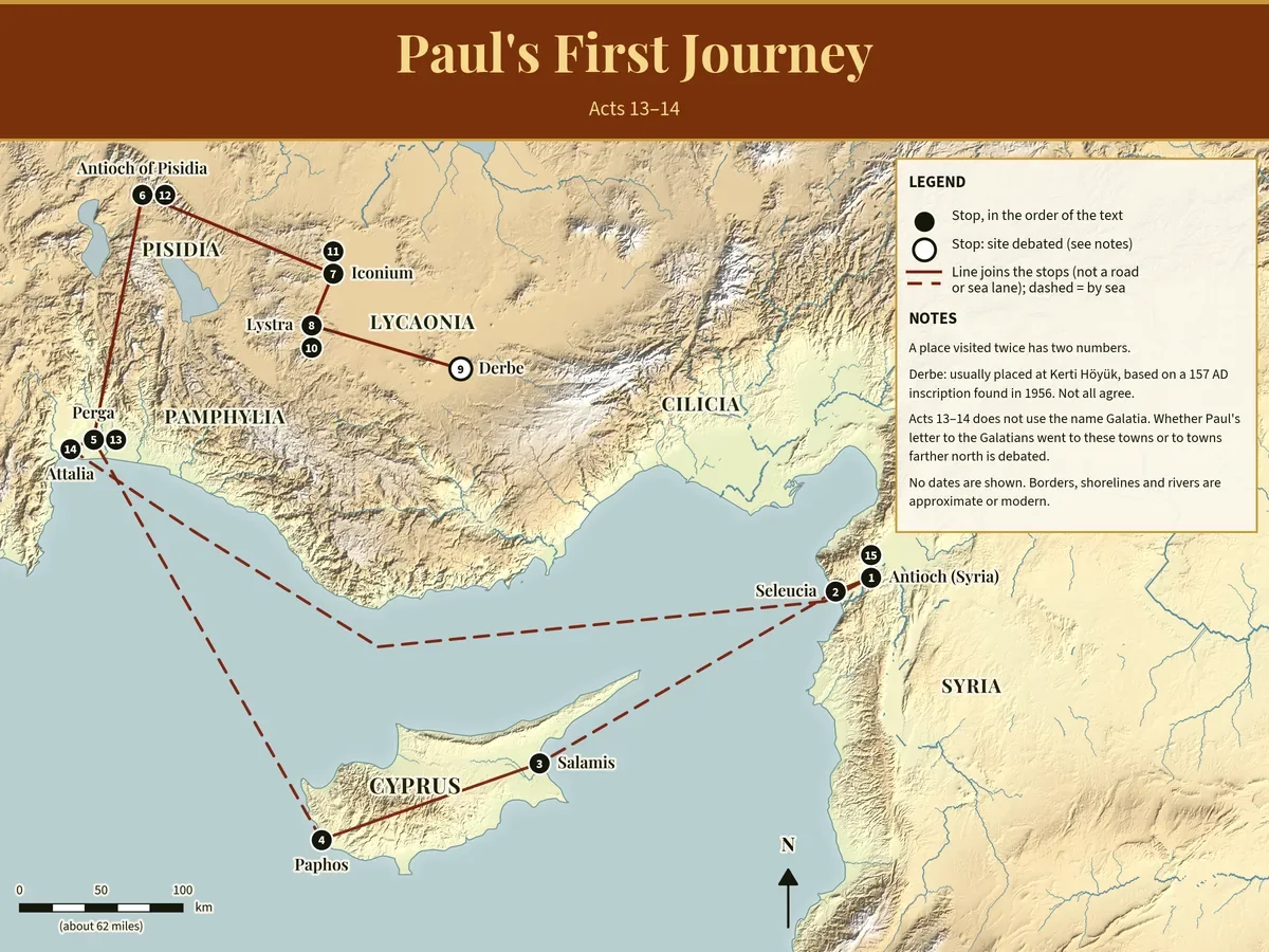
Map of Paul's first journey. From Antioch in Syria the route goes by sea to Cyprus (Salamis and Paphos), then to Perga, inland to Antioch of Pisidia, Iconium, Lystra and Derbe, and back through the same towns to Attalia and by sea to Antioch. Fifteen numbered stops.
Paul’s first journey, Acts 13–14. Dashed lines: the text says they sailed. Select the map to view it full size.

Verses: Acts 13–14 The Spread of Christianity

Regions on this map:

Sources and limits

  • The 15 numbers follow the order of Acts 13–14. A place visited twice has two numbers. Lines are not roads or sea lanes.
  • Derbe is usually placed at Kerti Höyük, from an inscription found in 1956. Not all agree, so its circle is open.
  • Acts 13–14 does not use the name Galatia. Whether Paul’s letter to the Galatians went to these towns or to towns farther north is debated.
  • Built by Bible Building Blocks from public-domain and open data: elevation from the US Geological Survey, coastlines and rivers from Natural Earth, and town points from Wikidata. Names follow the World English Bible, each checked against its verse. Shorelines are modern.
Journey 3

Paul’s Second Journey, Macedonia and Achaia

Paul crosses to Europe and preaches in Philippi, Thessalonica, Berea, Athens, and Corinth.

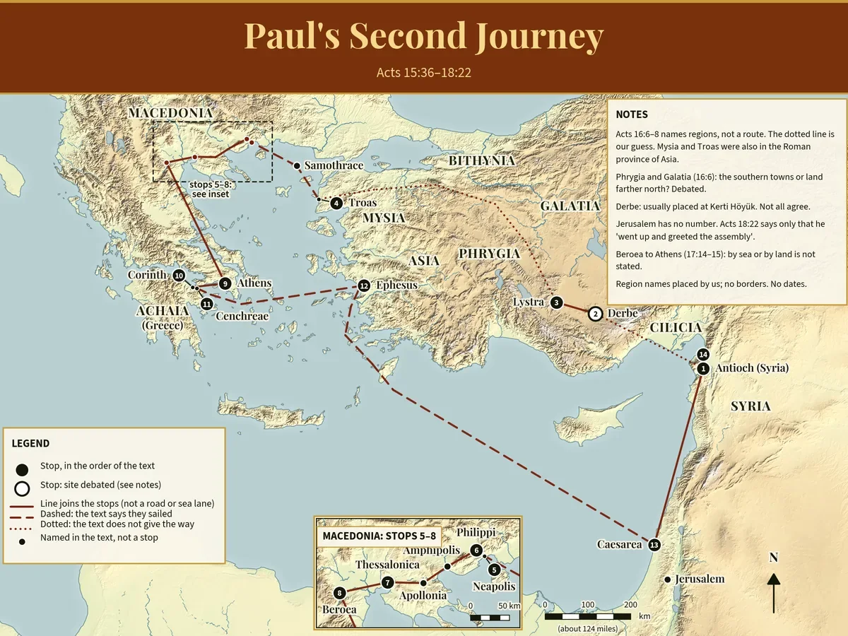
Map of Paul's second journey. From Antioch in Syria to Derbe and Lystra, a dotted line across Asia Minor to Troas, by sea to Macedonia (Neapolis, Philippi, Thessalonica, Beroea, shown in an inset), then Athens, Corinth and Cenchreae, by sea to Ephesus and Caesarea, and back to Antioch.
Paul’s second journey, Acts 15:36–18:22, with an inset for Macedonia. Select the map to view it full size.

Verses: Acts 15:36–18:22 The Spread of Christianity

Sources and limits

  • Acts 16:6–8 names regions, not a route, so the dotted line there is our guess. Mysia and Troas were also in the Roman province of Asia.
  • Samothrace, Amphipolis and Apollonia are named in the text but Paul passed through them, so they are plain dots. Jerusalem has no number, because Acts 18:22 says only that he went up and greeted the assembly.
  • Derbe’s site is debated. Whether “Phrygia and Galatia” (Acts 16:6) means the southern towns or the land farther north is also debated.
  • Built by Bible Building Blocks from public-domain and open data: elevation from the US Geological Survey, coastlines and rivers from Natural Earth, and town points from Wikidata. Names follow the World English Bible, each checked against its verse. Shorelines are modern.
Journey 4

Paul’s Third Journey

Paul spends about three years in Ephesus, revisits Macedonia and Greece, and returns to Jerusalem with a collection.

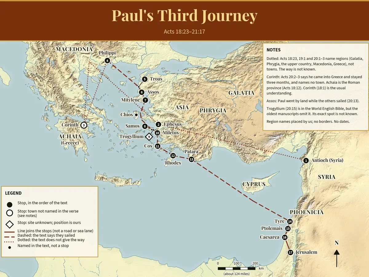
Map of Paul's third journey. A dotted line runs from Antioch in Syria across Asia Minor to Ephesus, on to Macedonia and Greece (Corinth, an open circle), back through Philippi and Troas, down the coast by Assos, Mitylene, Samos and Miletus, past Cos, Rhodes and Patara, and by sea to Tyre, Ptolemais, Caesarea and Jerusalem.
Paul’s third journey, Acts 18:23–21:17. Dotted lines: the text names regions, not towns. Select the map to view it full size.

Verses: Acts 18:23–21:17 The Spread of Christianity

Sources and limits

  • Acts 20:2–3 says Paul came into Greece and stayed three months, but names no town. Corinth is the usual understanding, so its circle is open.
  • Trogyllium (Acts 20:15) is in the World English Bible, but the oldest Greek manuscripts leave it out, and its exact spot is not known. Its position is ours.
  • Where the text names only regions (Acts 18:23; 19:1; 20:1–3), the way is not known and the line is dotted.
  • Built by Bible Building Blocks from public-domain and open data: elevation from the US Geological Survey, coastlines and rivers from Natural Earth, and town points from Wikidata. Names follow the World English Bible, each checked against its verse. Shorelines are modern.

Journey 5

Paul’s Journey to Rome

Paul is arrested in Jerusalem, held in Caesarea, and sent to Rome after appealing to Caesar.

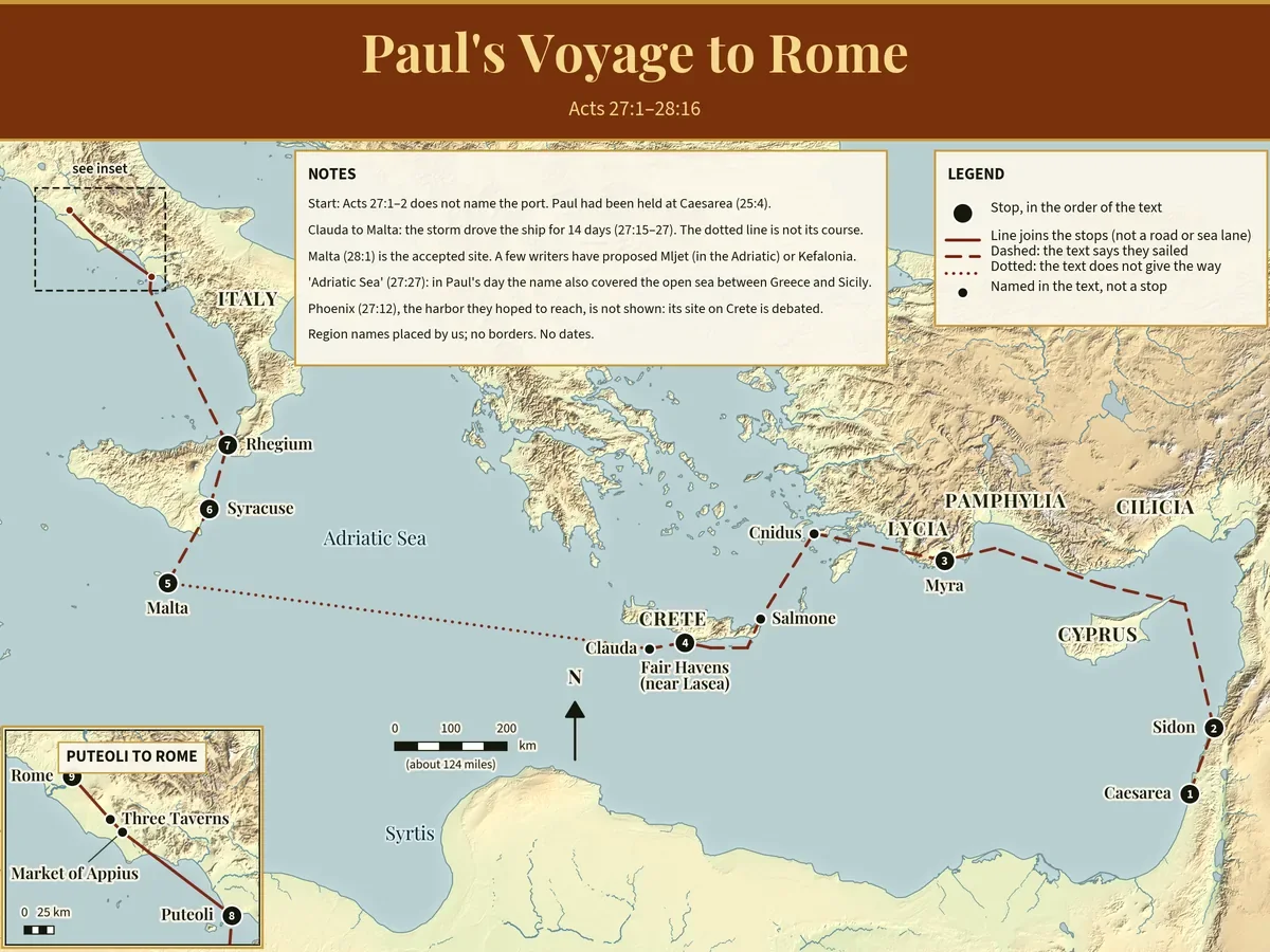
Map of Paul's voyage to Rome. From Caesarea the ship sails north to Sidon, along the coast to Myra, past Cnidus to Fair Havens on Crete, then a dotted line from Clauda to Malta for the storm, and on to Syracuse, Rhegium and Puteoli. An inset shows the road from Puteoli past the Market of Appius and Three Taverns to Rome.
Paul’s voyage to Rome as a prisoner, Acts 27:1–28:16, with an inset from Puteoli to Rome. Select the map to view it full size.

Verses: Acts 27:1–28:16 The Spread of Christianity

Regions on this map:

Sources and limits

  • Acts 27:1–2 does not name the port they left from. Paul had been held at Caesarea (Acts 25:4), so the map starts there.
  • From Clauda to Malta the storm drove the ship for fourteen days (Acts 27:15–27). The dotted line is not its course.
  • Malta (Acts 28:1) is the accepted site. A few writers have proposed Mljet in the Adriatic, or Kefalonia. Phoenix (Acts 27:12) is not shown because its site on Crete is debated.
  • Built by Bible Building Blocks from public-domain and open data: elevation from the US Geological Survey, coastlines and rivers from Natural Earth, and town points from Wikidata. Names follow the World English Bible, each checked against its verse. Shorelines are modern.